Momentick reports sub-10 kg/hour methane detection in controlled satellite study
The AMW Read
Controlled detection of a small methane release adds meaningful technical evidence for emissions analytics, but known source locations and unresolved operational reliability limit the impact to a specialized market.

Momentick reports sub-10 kg/hour methane detection in controlled satellite study
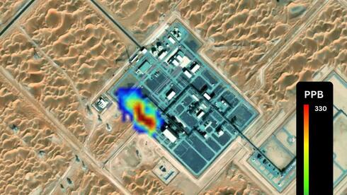
Israeli startup Momentick used WorldView-3 satellite imagery to detect a methane release it estimated at 9.47 kilograms per hour in a controlled experiment published in Nature. The Stanford-led study covered 746 test events in Arizona, including 481 methane releases and 265 no-emission controls. Fifteen analysis teams evaluated data from 12 satellites without knowing actual release rates. Momentick said it detected four of six releases below 100 kilograms per hour using WorldView-3.
The AI-market relevance lies in converting satellite imagery into measurements for energy operations and insurance underwriting. Momentick combines computer vision, algorithms and AI to identify emissions and estimate their volume, targeting decisions about repairs, lost gas and environmental risk. That places its commercial opportunity alongside enterprise operations and financial risk software: measurement reliability matters because customers may use the output to prioritize maintenance or assess coverage. The experiment provides evidence of detection capability under tested conditions, while leaving operational reliability an open question.
For builders and investors, the concrete diligence question is whether performance holds when source locations are unknown. Researchers knew approximate emission locations, so the study primarily tested detection and quantification at known sites. Cloud cover impaired detection, and some AI-based methods generated false positives. Buyers evaluating Momentick should distinguish the smallest detected release from a dependable detection threshold and seek evidence on missed leaks and false alarms in broader searches before using satellite estimates for repair or underwriting decisions.